Integrating GIS in TOCCI’s BIM Toolbox
Share
SmartAsset Management Solution – GIS + BIM Integration
In a great turn for TOCCI’s expanding services, our firm has joined ESRI’s business network and integrated their GIS technology in our standard BIM-focused workflow, improving project close-out.
GIS (Geographic Information System)’s platform visualizes and analyzes spatial data. Intuitively, it shows us the “what” and “where”, similar to Google Maps.
GIS is a lifeline at the end of construction when owners are handed the keys, but left with piles of as-built information (plans, product cut sheets, warranty letters) in three ring binders and hard drives. Detailed, but inefficient for busy owners; binders are heavy, easily misplaced, and require extensive construction knowledge.
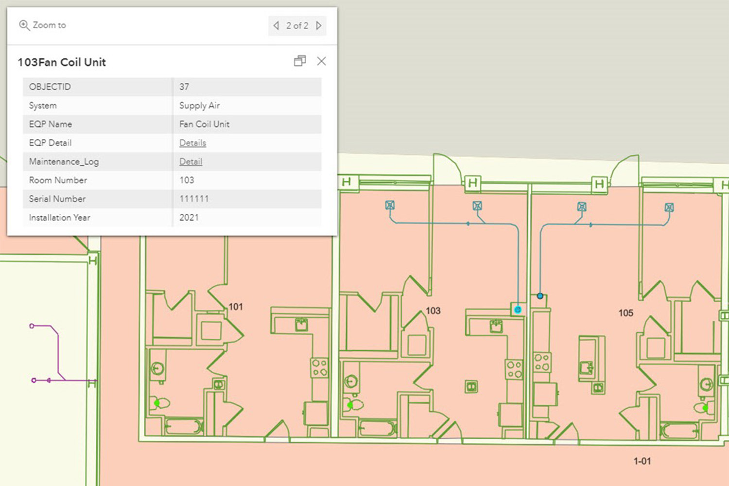
TOCCI recognizes owners need information about every system and component at their fingertips. With a newly integrated workflow, BIM data (3D models and 2D drawings) is converted to GIS data, where information is presented in an interactive map. Walls, doors, and windows in the design models are now lines and shapes, and assets (plumbing fixtures, HVAC equipment, appliances) are points of interest (dots).
For example, a fan coil unit appears as a blue dot, that once clicked opens to product data and maintenance records. The supply air ductwork connected to the unit (a blue line) facilitates maintenance, repair, and replacement activities.
Owners can refer to the map instead of wade through paperwork, and facility managers can find product cut sheets (of the fan coil unit, for example) by panning to specific points. GIS removes the hunt for information; it’s simply “click and go”.
NEW SERVICES
Infused with BIM-GIS integration, TOCCI offers a variety of services for the following customers in different situations:
• Commercial real estate developers: Delivery of facility maps with as-built information at the end of construction, and data hosting in either the client’s premises or a secure cloud environment.
• Property owners and operators (universities and hospitals): Partnership with ESRI to offer clients an advanced indoor mapping application: ArcGIS Indoor. It provides powerful functionalities like space management, work order management, route calculation, and more.
• Existing ArcGIS Indoor/other ESRI products customers: Construction/Program Management services with a focus on BIM-GIS integration. In addition to the normal duties of a construction/program manager, we collaborate with your GIS professionals to seamlessly integrate as-built data in your facility management systems.